Build sidewalks, drop speed limits and boost school zone safety: how transportation plan aims to make city more walkable
Part one of a three-part series about how Peterborough’s new transportation master plan will transform how people get around the city for decades to come.
Update: Council gave final approval to the plan to spend $30 million a year on transportation infrastructure over 30 years – $908 million in total – on Monday March 28.
City council will vote on the broad strokes of a proposal to spend an estimated $30 million a year on roads, sidewalks, cycling lanes and transit infrastructure over the next three decades, at Monday’s general committee meeting (March 14).
That’s how much it will cost to implement the projects proposed in Peterborough’s new transportation master plan, close to completion after almost two years of studies and public consultations.
The figure is 43 percent above the $21 million annually the city has spent on transportation infrastructure in recent years, according to a staff report.
The new long-range plan lays out a roadmap for how the city’s streets, sidewalks, cycling lanes and transit system will adapt to a growing population, forecast to hit 125,000 by 2051.
A key plank of the strategy is to urge a shift away from car travel, by making it easier to get around by bicycle, bus and on foot.
Right now, the vast majority of trips Peterborough residents make on a given day are by car. Cycling, transit and walking only account for about one in four trips, according to a staff report.
Last fall, council adopted a target of gradually increasing that share over the coming decades, so that by the middle of the century, about one third of all trips in the city will be made by cycling, walking and transit.
Some have argued for a more ambitious shift away from car dependence, in order to cut Peterborough’s greenhouse gas emissions further. But the current targets will still require significant changes to make the city more pedestrian and cyclist friendly and transit more convenient and reliable.
How will that change your commute to work and trips to the grocery store? This is part one of a three part series, looking at how the transportation master plan will reshape how people get around the city. First up, we look at some of the proposals to boost walking.
“Aggressive” investment in sidewalks
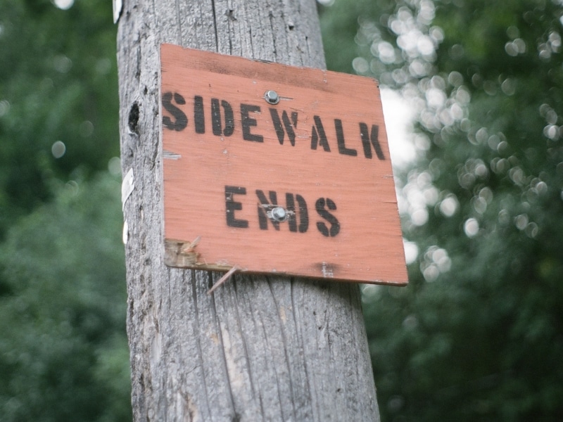
Where does the sidewalk end? In Peterborough, lots of places. City hall has a long list of streets that are missing sections of sidewalk – like major arteries such as Chemong Road and Hunter Street E., as well as residential streets such as Alexander Court and Dublin Street.
Staff are recommending that the City build 100-150 kilometres of new sidewalks over the next 30 years to fill some of those gaps, according to a report to Monday’s general committee meeting. The estimated price tag is $64 million.
Council has already voted to make “aggressive” investments in sidewalk construction as part of the transportation master plan, in order to encourage more people to walk. The focus would be on the downtown, new growth areas and along transit routes.
City hall already has a strategic plan for completing the sidewalk network, with a goal of having
one along both sides of every street. As of 2016, it was just over halfway there, with 367.5 kilometres left to build, according to the latest figures available.
But additional progress has been slow, with only about two kilometres of new sidewalks being built each year, according to the City’s website. The proposed funding would see between three and five kilometres laid per year.
“If we’re going to actually shift people’s behaviour and get people out of their cars, they need the infrastructure to do it properly,” said transportation division manager Kevin Jones at a public consultation on the transportation master plan in February.
Some of the gaps in the city’s sidewalks are hard to fill because of mature trees, embankments and retaining walls near the street, according to the sidewalk strategic plan. Homeowners can also be a barrier sometimes.
“It’s always a balance on sidewalk construction: some people love them, some people hate them, when it affects their parking and the driveway,” Jones said.
Lower speed limits in school zones and downtown
When a 16-year-old student was critically injured after being struck by a vehicle in front of his high school last September, Peterborough Currents reported that there were no signs on the street to mark it as a school zone.
No charges were laid and it’s not known if speeding was a factor in the collision, but it raised concerns about safety on Hilliard Street, where Adam Scott Collegiate and Vocational Institute and Intermediate School is located.
Now the City is considering enhanced safety measures in school zones as part of a broader “road safety plan,” which would feed into the transportation master plan. Some of the ideas on the table include lower speed limits around schools and consistent signage and road markings to indicate that students are present.
The City is also considering dropping the speed limit in parts of the downtown, as part of the plan – something that has already been experimented with during the COVID-19 pandemic.
Last summer, sections of Hunter and Charlotte streets were reduced to one lane of traffic each, allowing restaurants to have larger patios while public health restrictions on indoor dining were in place. Similar temporary changes were made to a stretch of George Street in 2020, to allow for more outdoor dining space and to give pedestrians more space to socially distance. The speed limit on those streets was also temporarily reduced to 30 km/h.
“People aren’t driving very fast through the downtown anyway,” said Jones, at February’s public consultation on the transportation master plan. “It’s busy, there’s a lot going on, there’s a lot of pedestrians, there’s a lot to look out for – and a slower speed probably makes a lot of sense.”
Jones said those projects were “quite successful,” especially last summer’s temporary redesign of Hunter and Charlotte streets. “We kind of see that as probably a model moving forward, even when we come out of COVID, where we might take away some of the space for parking and allow some pop up patios to happen in the downtown.”
Giving pedestrians a head start crossing intersections
In recent years many cities have begun re-timing crosswalk signals to give pedestrians a five-second or so head start crossing streets, before vehicles get a green light.
That’s something city hall is considering for some intersections in Peterborough in order to boost safety and encourage more people to walk, according to Jones.
Advanced walk signals have been shown to reduce collisions between pedestrians and vehicles by as much as 60 percent, according to the U.S.’s National Association of City Transportation Officials.
City staff haven’t identified what intersections could get the early signals, which transportation planners call “leading pedestrian intervals,” wrote communication services manager Brendan Wedley. But they have been ruled out for intersections that already have advanced green signals for cars, as having both “would put vehicles and pedestrians into conflict,” Wedley wrote.
“You got to be very careful where you do it,” Jones said of introducing advanced walk signals. “You can do it in very strategic locations.”
There is also some concern that leading pedestrian intervals could increase traffic delays and thus lead to more vehicle emissions from idling, Wedley wrote. “So the City would need to carefully assess each location to determine the potential benefits and drawbacks for these types of treatments on a case by case basis.”
Author

Related Articles
Riel commits to investing in buses
Would support Transportation Master Plan as mayor, despite uneven record as councillor
What do transit users think of the transit system?
Most voters in Peterborough never ride the bus

“Disappointing”: Peterborough moves away from traffic calming, despite data showing pilot projects led to reduced speeds
Councillors vote to study lowering speed limit to 40 km/hr city-wide instead